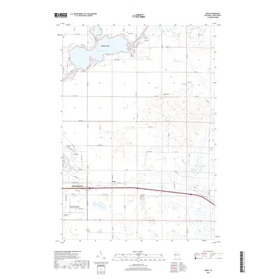
2018 Map of Rusk
USGS Topo · Published 2018About this map
The Red Cedar River and Tainter Lake dominate the northern landscape of this Dunn County quadrangle, where the small settlement of Rusk sits at the intersection of local rail and road networks. To the southwest, the outskirts of Menomonie are anchored by the Menomonie Municipal Airport-Score Field. The terrain transitions from these water bodies and developed areas into the high ground of Hanke Hill and the low-lying Elk Mound Marsh. Genealogists and local historians can locate several burial sites throughout the township, including Hill Grove Cem in the northeast, Cedar Falls Cem near the river, and the Potters Field Cem located south of the airport. The grid-like arrangement of rural roads like Co RD E and Co RD BB frames a mix of agricultural land and scattered wetlands fed by Sinking Cr and Muddy Cr.
Find a feature on this map
49 named features on this map. Tap any name to fly to it.
Don’t see what you’re looking for? This feature index may not catch every label — zoom into the map to look around manually.
Map Details
Editions of this 2018 Rusk Map
This is the sole edition of this map. No revisions or reprints were ever made.
Other maps of this area

1934 · Elk Mound
USGS Topo · 1:62,500

1936 · Elk Mound
USGS Topo · 1:62,500

1940 · Menomonie
USGS Topo · 1:62,500

1942 · Menomonie
USGS Topo · 1:62,500

1949 · New Auburn
USGS Topo · 1:62,500

1949 · Ridgeland
USGS Topo · 1:62,500

1951 · Ridgeland
USGS Topo · 1:62,500

1951 · New Auburn
USGS Topo · 1:62,500

1953 · Eau Claire
USGS Topo · 1:250,000

1953 · Rice Lake
USGS Topo · 1:250,000