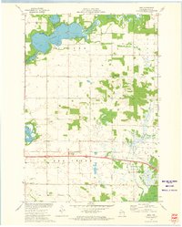
1972 Map of Rusk
USGS Topo · Published 1975About this map
The Red Cedar River flows through the northern reaches of this rural landscape, feeding into the expansive Tainter Lake as it stood in the early 1970s. The settlement of Rusk serves as a central hub, situated along the Chicago and North Western rail line and Interstate 94. This period reflects a transition in land use, where the industrial infrastructure of a weigh station and Rest Area meets long-established local landmarks like Hanke Hill. A significant network of rural life is visible through numerous cemeteries and churches, including the Potters Field Cem and St Katherine Ch. To the southeast, the Muddy Creek State Public Hunting Grounds preserves the marshy terrain and natural creek beds, offering a look at the preserved wetlands of Dunn County before modern expansion further altered the local drainage patterns.
Find a feature on this map
35 named features on this map. Tap any name to fly to it.
Don’t see what you’re looking for? This feature index may not catch every label — zoom into the map to look around manually.
Map Details
Editions of this 1972 Rusk Map
This is the sole edition of this map. No revisions or reprints were ever made.
Other maps of this area

1934 · Elk Mound
USGS Topo · 1:62,500

1936 · Elk Mound
USGS Topo · 1:62,500

1940 · Menomonie
USGS Topo · 1:62,500

1942 · Menomonie
USGS Topo · 1:62,500

1949 · New Auburn
USGS Topo · 1:62,500

1949 · Ridgeland
USGS Topo · 1:62,500

1951 · Ridgeland
USGS Topo · 1:62,500

1951 · New Auburn
USGS Topo · 1:62,500

1953 · Eau Claire
USGS Topo · 1:250,000

1953 · Rice Lake
USGS Topo · 1:250,000