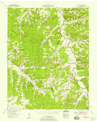
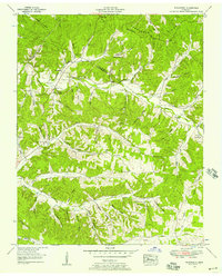
1953 Map of Ruskin
USGS Topo · Published 1958About this map
Nubbin Ridge and the Tennessee Valley divide dominate this mid-century landscape where Houston, Dickson, and Humphreys counties meet. The area is characterized by a dense network of hollows, such as Tubbs Hollow and Biffle Hollow, which served as the primary conduits for settlement and transit before modern highway expansion. A high concentration of family cemeteries, including Dickson Cem, Balthrop Cem, and Nesbitt Cem, are located in the ridges and valleys, providing significant data for genealogical research. Small community centers like Ruskin and Edgewood anchor the rural landscape, while Jewel Cave and its nearby Swimming Pool suggest a history of local recreation and landmark tourism. The reliance on natural water sources is evident through the naming of Bradford Spring and Vanhook Spring, which supported the surrounding upland farms and crossroads like Adams Crossroads.
Find a feature on this map
77 named features on this map. Tap any name to fly to it.
Don’t see what you’re looking for? This feature index may not catch every label — zoom into the map to look around manually.
Map Details
Editions of this 1953 Ruskin Map
3 editions found
Other maps of this area

1931 · Erin
USGS Topo · 1:62,500

1936 · Gorman
USGS Topo · 1:24,000

1936 · Tantrough Hollow
USGS Topo · 1:24,000

1936 · Woolworth
USGS Topo · 1:24,000

1936 · Ruskin
USGS Topo · 1:24,000

1936 · Tennessee City
USGS Topo · 1:24,000

1936 · Dickson
USGS Topo · 1:24,000
1952 · Mc Ewen
USGS Topo · 1:24,000
1952 · Woolworth
USGS Topo · 1:24,000

1953 · Dickson
USGS Topo · 1:24,000