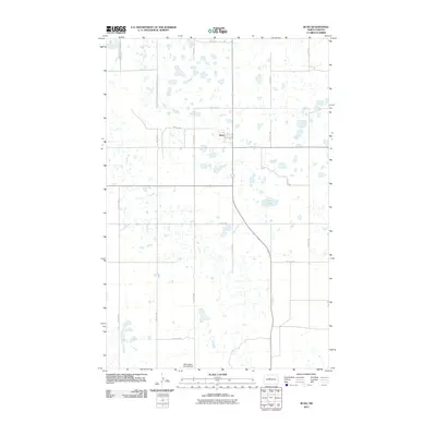
2011 Map of Ruso
USGS Topo · Published 2011About this map
Ruso stands as the primary hub of this McLean County landscape, positioned within a rhythmic grid of rural roads and an extensive network of prairie potholes. The geography is defined by hundreds of small, scattered water bodies that characterize this portion of the North Dakota plains, with Otis Lake serving as one of the few larger named basins in the eastern section of the quadrangle. Transportation is rooted in a strict rectangular survey system, where routes like 30th St N and 17th Ave NW intersect to provide access to the surrounding agricultural land. In the southern portion of the map, the Willoughby Landing Field indicates the continued importance of light aviation for these rural communities. This 2011 survey, published by the U.S. Geological Survey, captures the precise infrastructure of the era, from the residential alignment along Main St to the isolated farm access roads like 24th St NW.
Find a feature on this map
21 named features on this map. Tap any name to fly to it.
Don’t see what you’re looking for? This feature index may not catch every label — zoom into the map to look around manually.
Map Details
Editions of this 2011 Ruso Map
This is the sole edition of this map. No revisions or reprints were ever made.
Other maps of this area

1929 · Coleharbor
USGS Topo · 1:62,500

1929 · Benedict
USGS Topo · 1:62,500

1929 · Kongsberg
USGS Topo · 1:62,500

1947 · Turtle Lake
USGS Topo · 1:62,500

1954 · McClusky
USGS Topo · 1:250,000

1958 · McClusky
USGS Topo · 1:250,000
1958 · Kongsberg NE
USGS Topo · 1:24,000

1974 · Benedict SE
USGS Topo · 1:24,000
1974 · Kongsberg SW
USGS Topo · 1:24,000
1974 · Kongsberg NW
USGS Topo · 1:24,000