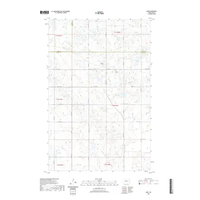
2020 Map of Ruso
USGS Topo · Published 2020About this map
Ruso sits at the junction of several rural routes in a landscape defined by North Dakota's characteristic prairie potholes and wetlands. This 2020 survey documents the town and its immediate surroundings, including the Ruso Lutheran Cem located just to the east. The terrain is remarkably intricate, dotted with hundreds of small seasonal basins and larger permanent bodies of water like Otis Lake, illustrating the glacial topography of the region. This map provides a clear record of the intersection between human infrastructure—such as Co Hwy 25 and the grid of township roads like 29th St NW—and the natural drainage patterns that dominate McLean and Ward counties. The boundary lines for McHenry and Ward counties are also clearly delineated, showing how these administrative borders bisect the open agricultural land and wetland complexes.
Find a feature on this map
21 named features on this map. Tap any name to fly to it.
Don’t see what you’re looking for? This feature index may not catch every label — zoom into the map to look around manually.
Map Details
Editions of this 2020 Ruso Map
This is the sole edition of this map. No revisions or reprints were ever made.
Other maps of this area

1929 · Coleharbor
USGS Topo · 1:62,500

1929 · Benedict
USGS Topo · 1:62,500

1929 · Kongsberg
USGS Topo · 1:62,500

1947 · Turtle Lake
USGS Topo · 1:62,500

1954 · McClusky
USGS Topo · 1:250,000

1958 · McClusky
USGS Topo · 1:250,000
1958 · Kongsberg NE
USGS Topo · 1:24,000

1974 · Benedict SE
USGS Topo · 1:24,000
1974 · Kongsberg SW
USGS Topo · 1:24,000
1974 · Kongsberg NW
USGS Topo · 1:24,000