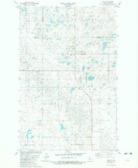
1981 Map of Ruso
USGS Topo · Published 1982About this map
Ruso stands at the center of this prairie landscape, a small settlement positioned along the Soo Line railroad tracks near the border of McHenry and McLean counties. The surrounding terrain is defined by the glacial pothole geography of the Missouri Coteau, where countless small wetlands and depressions dot the landscape. To the south, the broad depression of Horseshoe Valley transitions into the upland plains of Otis and Andrews. Conservation areas are prominent in this quadrant, notably the Lake Otis National Wildlife Refuge and a designated National Waterfowl Production Area, highlighting the region's importance for migratory birds. Local history is anchored by the Ruso Cem and the former sites of Bauer and Boozinny, along with a rural Townhall located southeast of Otis Lake.
Find a feature on this map
20 named features on this map. Tap any name to fly to it.
Don’t see what you’re looking for? This feature index may not catch every label — zoom into the map to look around manually.
Map Details
Editions of this 1981 Ruso Map
This is the sole edition of this map. No revisions or reprints were ever made.
Other maps of this area

1929 · Coleharbor
USGS Topo · 1:62,500

1929 · Benedict
USGS Topo · 1:62,500

1929 · Kongsberg
USGS Topo · 1:62,500

1947 · Turtle Lake
USGS Topo · 1:62,500

1954 · McClusky
USGS Topo · 1:250,000

1958 · McClusky
USGS Topo · 1:250,000
1958 · Kongsberg NE
USGS Topo · 1:24,000

1974 · Benedict SE
USGS Topo · 1:24,000
1974 · Kongsberg SW
USGS Topo · 1:24,000
1974 · Kongsberg NW
USGS Topo · 1:24,000