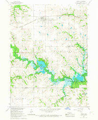
1966 Map of Russell
USGS Topo · Published 1967About this map
Russell serves as the primary rail-side settlement on this mid-1960s Iowa landscape, positioned along the Chicago Burlington and Quincy railroad. The map captures a significant period of transformation as the Chariton River valley prepares for inundation. Blue hatching across the central terrain indicates extensive areas designated to be submerged by the Rathbun Reservoir, a project that redefined the local geography and habitat.
Find a feature on this map
23 named features on this map. Tap any name to fly to it.
Don’t see what you’re looking for? This feature index may not catch every label — zoom into the map to look around manually.
Map Details
Editions of this 1966 Russell Map
This is the sole edition of this map. No revisions or reprints were ever made.
Other maps of this area

1918 · Chariton
USGS Topo · 1:62,500

1924 · Melcher
USGS Topo · 1:62,500

1934 · Humeston
USGS Topo · 1:48,000

1935 · Russell
USGS Topo · 1:62,500

1937 · Corydon
USGS Topo · 1:62,500

1938 · Russell
USGS Topo · 1:62,500

1954 · Centerville
USGS Topo · 1:250,000

1954 · Des Moines
USGS Topo · 1:250,000

1956 · Des Moines
USGS Topo · 1:250,000

1957 · Des Moines
USGS Topo · 1:250,000