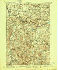
1918 Map of Russell
USGS Topo · Published 1929About this map
The Grass River winds through this rural St. Lawrence County landscape, defining the character of North Country settlements during the early twentieth century. This area is a patchwork of small crossroad hamlets and local landmarks, including the notable Clifton Furnace (Ruins) and the busy junction at Monterey De Grasse PO. The map reveals a highly decentralized educational network, with dozens of rural schools like the Castle Street School and Scotland School serving isolated agricultural and industrial pockets.
Find a feature on this map
121 named features on this map. Tap any name to fly to it.
Don’t see what you’re looking for? This feature index may not catch every label — zoom into the map to look around manually.
Map Details
Editions of this 1918 Russell Map
5 editions found

Other maps of this area

1904 · Ogdensburg
USGS Topo · 1:62,500

1905 · Ogdensburg
USGS Topo · 1:62,500

1908 · Potsdam
USGS Topo · 1:62,500

1910 · Canton
USGS Topo · 1:62,500

1911 · Canton
USGS Topo · 1:62,500

1913 · Lake Bonaparte
USGS Topo · 1:62,500

1915 · Gouverneur
USGS Topo · 1:62,500

1915 · Russell
USGS Topo · 1:62,500

1916 · Lake Bonaparte
USGS Topo · 1:62,500

1916 · Oswegatchie
USGS Topo · 1:62,500