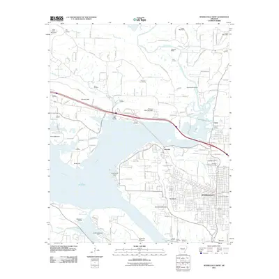
2011 Map of Russellville West
USGS Topo · Published 2011About this map
Russellville and the surrounding Pope County landscape are defined by the convergence of the Arkansas River and the Illinois Bayou in this early twenty-first-century survey. The western expansion of the city is evident as it reaches toward the shores of Lake Dardanelle, with the Arkansas Technical University campus serving as a major institutional anchor on the eastern edge of the map. Smaller, established communities like Norristown, Ouitaville, and Shiloh dot the northern and western outskirts, often positioned near significant terrain features like Norristown Mountain and Pleasant View Mountain.
Find a feature on this map
153 named features on this map. Tap any name to fly to it.
Don’t see what you’re looking for? This feature index may not catch every label — zoom into the map to look around manually.
Map Details
Editions of this 2011 Russellville West Map
This is the sole edition of this map. No revisions or reprints were ever made.
Other maps of this area

1888 · Dardanelle #4
USGS Topo · 1:62,500

1888 · Dardanelle #2
USGS Topo · 1:62,500

1888 · Dardanelle #1
USGS Topo · 1:62,500

1888 · Dardanelle #3
USGS Topo · 1:62,500

1890 · Dardanelle
USGS Topo · 1:125,000

1956 · Russellville
USGS Topo · 1:250,000
1961 · Dover
USGS Topo · 1:24,000
1962 · Knoxville
USGS Topo · 1:24,000
1962 · Russellville East
USGS Topo · 1:24,000

1962 · Delaware
USGS Topo · 1:24,000