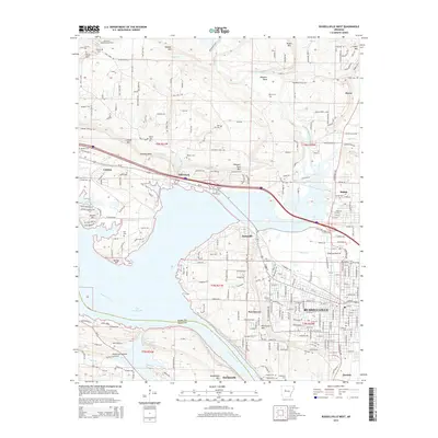
2014 Map of Russellville West
USGS Topo · Published 2014About this map
Lake Dardanelle and the Arkansas River dominate this landscape, illustrating the water-driven geography of Pope and Yell counties. The city of Russellville anchors the eastern side, showing a transition from dense urban blocks to the sprawling fields of Chactas Prairie. Notable historic routes like Old Wire Rd E trace the path of early communication and travel near the community of London. Local history is preserved in numerous family and community burial grounds, including Reed Cem and Oakland Cem, which sit amidst the modern street grid. Higher elevations like London Mtn and Point Mtn overlook the industrial activity of the Knoxville Extension Gas Field, while small settlements like Norristown and Ouitaville mark the shoreline where the river meets the surrounding bluffs.
Find a feature on this map
55 named features on this map. Tap any name to fly to it.
Don’t see what you’re looking for? This feature index may not catch every label — zoom into the map to look around manually.
Map Details
Editions of this 2014 Russellville West Map
This is the sole edition of this map. No revisions or reprints were ever made.
Other maps of this area

1888 · Dardanelle #4
USGS Topo · 1:62,500

1888 · Dardanelle #2
USGS Topo · 1:62,500

1888 · Dardanelle #1
USGS Topo · 1:62,500

1888 · Dardanelle #3
USGS Topo · 1:62,500

1890 · Dardanelle
USGS Topo · 1:125,000

1956 · Russellville
USGS Topo · 1:250,000
1961 · Dover
USGS Topo · 1:24,000
1962 · Knoxville
USGS Topo · 1:24,000
1962 · Russellville East
USGS Topo · 1:24,000

1962 · Delaware
USGS Topo · 1:24,000