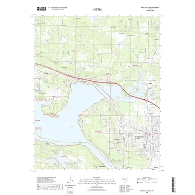
2020 Map of Russellville West
USGS Topo · Published 2020About this map
Arkansas Tech University and the Pope County Courthouse anchor the eastern edge of this landscape, representing the civic and educational hub of Russellville. The area transitions from the dense street grids of the city toward the industrial history found at the Ouita Coal Company near the Lake Dardanelle shoreline. Further west, the map follows the corridor of I-40 and US Highway 64 through the settlements of London and Mill Creek. Numerous family and community burial grounds, including Swann Cemetery, Booher Cemetery, and Bailey Cemetery, are scattered across the terrain from the slopes of London Mountain to the banks of Illinois Bayou. The southern portion of the map is dominated by the waters of the Arkansas River valley, showing the complex interface between the developed city and the prominent heights of Norristown Mountain and Dardanelle Mountain.
Find a feature on this map
54 named features on this map. Tap any name to fly to it.
Don’t see what you’re looking for? This feature index may not catch every label — zoom into the map to look around manually.
Map Details
Editions of this 2020 Russellville West Map
This is the sole edition of this map. No revisions or reprints were ever made.
Other maps of this area

1888 · Dardanelle #4
USGS Topo · 1:62,500

1888 · Dardanelle #2
USGS Topo · 1:62,500

1888 · Dardanelle #1
USGS Topo · 1:62,500

1888 · Dardanelle #3
USGS Topo · 1:62,500

1890 · Dardanelle
USGS Topo · 1:125,000

1956 · Russellville
USGS Topo · 1:250,000
1961 · Dover
USGS Topo · 1:24,000
1962 · Knoxville
USGS Topo · 1:24,000
1962 · Russellville East
USGS Topo · 1:24,000

1962 · Delaware
USGS Topo · 1:24,000