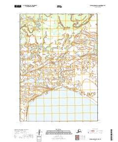
2019 Map of Russian Mission B-3 NW
USGS Topo · Published 2019About this map
Whitefish Lake dominates the southern reaches of this landscape in the Bethel Census Area, its broad waters providing a massive contrast to the intricate wetlands to the north. This 2019 survey documents a vast lacustrine and riverine environment where Discovery Creek meanders through the upper terrain. The area is defined by the rigid grid of the Public Land Survey System, spanning townships such as t16n r60w and t15n r60w. The map preserves the exact hydrological patterns of the Yukon-Kuskokwim Delta region, illustrating the complex network of unnamed ponds and marshes that surround these primary water bodies. For those studying the remote geography of western Alaska, this sheet provides an essential look at the land's character before natural shifting or climate-driven changes alter the shoreline of the lake or the path of the creek.
Find a feature on this map
7 named features on this map. Tap any name to fly to it.
Don’t see what you’re looking for? This feature index may not catch every label — zoom into the map to look around manually.
Map Details
Editions of this 2019 Russian Mission B-3 NW Map
This is the sole edition of this map. No revisions or reprints were ever made.
Other maps of this area

1947 · Russian Mission
USGS Topo · 1:250,000

1950 · Russian Mission
USGS Topo · 1:250,000

1952 · Russian Mission C-3
USGS Topo · 1:63,360

1952 · Russian Mission B-3
USGS Topo · 1:63,360

1954 · Russian Mission C-4
USGS Topo · 1:63,360

1954 · Russian Mission B-4
USGS Topo · 1:63,360

1980 · Russian Mission
USGS Topo · 1:250,000
2017 · Russian Mission B-4 NE
USGS Topo · 1:25,000
2017 · Russian Mission C-4 SE
USGS Topo · 1:25,000
2017 · Russian Mission B-4 SE
USGS Topo · 1:25,000