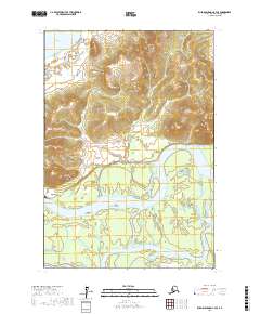
2017 Map of Russian Mission C-4 SE
USGS Topo · Published 2017About this map
The Kuskokwim River serves as the dominant geographical feature in this portion of the Bethel Census Area, winding through a landscape defined by expansive lowlands and the southern rises of the Portage Mountains. The settlement of Kalskag is positioned on the north bank of the river, representing a vital hub of activity in an area where the water dictates the rhythm of travel and resource access. To the north, Arhymot Lake sits within a complex of wetlands, while the braided channels of Discovery Creek meander through the southern flats. The transition from the steep elevations of the Portage Mountains to the riparian environment of the Kuskokwim valley illustrates the topographic diversity of the Yukon-Kuskokwim Delta region. This map provides a detailed view of the township and range divisions, showing how the Public Land Survey System overlay interacts with the natural hydrology and terrain of western Alaska.
Find a feature on this map
11 named features on this map. Tap any name to fly to it.
Don’t see what you’re looking for? This feature index may not catch every label — zoom into the map to look around manually.
Map Details
Editions of this 2017 Russian Mission C-4 SE Map
This is the sole edition of this map. No revisions or reprints were ever made.
Other maps of this area

1947 · Russian Mission
USGS Topo · 1:250,000

1950 · Russian Mission
USGS Topo · 1:250,000

1952 · Russian Mission C-3
USGS Topo · 1:63,360

1952 · Russian Mission B-3
USGS Topo · 1:63,360

1954 · Russian Mission C-4
USGS Topo · 1:63,360

1954 · Russian Mission B-4
USGS Topo · 1:63,360

1980 · Russian Mission
USGS Topo · 1:250,000
2017 · Russian Mission B-4 NE
USGS Topo · 1:25,000
2017 · Russian Mission C-4 NE
USGS Topo · 1:25,000
2017 · Russian Mission B-4 NW
USGS Topo · 1:25,000