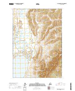
2017 Map of Russian Mission C-4 NE
USGS Topo · Published 2017About this map
Arhymot Lake dominates the southwestern corner of this survey within the Bethel Census Area, serving as the primary landmark in an otherwise unpopulated landscape. The terrain is defined by a striking transition from the lake-studded lowlands in the west to the significant topographical elevations of the eastern quadrants, where the land rises sharply above the marshy plains. The Public Land Survey System grid, including t19n r61w, t19n r60w, t18n r61w, and t18n r60w, provides the only human-imposed structure across this interior Alaskan wilderness. This specific alignment of water and high ground illustrates the geological interface between the alluvial basins and the surrounding uplands near the Russian Mission region.
Find a feature on this map
5 named features on this map. Tap any name to fly to it.
Don’t see what you’re looking for? This feature index may not catch every label — zoom into the map to look around manually.
Map Details
Editions of this 2017 Russian Mission C-4 NE Map
This is the sole edition of this map. No revisions or reprints were ever made.
Other maps of this area

1947 · Russian Mission
USGS Topo · 1:250,000

1950 · Russian Mission
USGS Topo · 1:250,000

1952 · Russian Mission D-3
USGS Topo · 1:63,360

1952 · Russian Mission C-3
USGS Topo · 1:63,360

1952 · Russian Mission D-4
USGS Topo · 1:63,360

1954 · Russian Mission C-4
USGS Topo · 1:63,360

1980 · Russian Mission
USGS Topo · 1:250,000
2017 · Russian Mission D-4 SW
USGS Topo · 1:25,000
2017 · Russian Mission D-4 SE
USGS Topo · 1:25,000
2017 · Russian Mission C-4 SE
USGS Topo · 1:25,000