
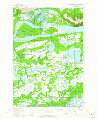
1952 Map of Russian Mission D-4
USGS Topo · Published 1962About this map
The Yukon River dominates this 1952 topographic study, carving a wide path beneath the rising elevations of the Paimiut Mountains. The landscape is defined by a complex hydrologic network of interconnected waterways, where the main river channel is flanked by a series of significant side channels including Twelvemile Slough and Paimiut Slough. This intricate lattice of water and silt suggests a dynamic environment where seasonal shifts dictate movement across the terrain.
Find a feature on this map
9 named features on this map. Tap any name to fly to it.
Don’t see what you’re looking for? This feature index may not catch every label — zoom into the map to look around manually.
Map Details
Editions of this 1952 Russian Mission D-4 Map
This is the sole edition of this map. No revisions or reprints were ever made.
Other maps of this area

1947 · Russian Mission
USGS Topo · 1:250,000

1950 · Russian Mission
USGS Topo · 1:250,000

1951 · Holy Cross
USGS Topo · 1:250,000

1952 · Holy Cross A-4
USGS Topo · 1:63,360

1952 · Holy Cross A-3
USGS Topo · 1:63,360

1952 · Holy Cross
USGS Topo · 1:250,000

1952 · Russian Mission D-3
USGS Topo · 1:63,360

1952 · Russian Mission C-3
USGS Topo · 1:63,360

1952 · Russian Mission C-5
USGS Topo · 1:63,360
1952 · Russian Mission D-5
USGS Topo · 1:63,360