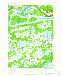
1952 Map of Russian Mission D-5
USGS Topo · Published 1962About this map
The Yukon River dominates this mid-century landscape, carving a wide path through an intricate network of waterways and islands. Large landmasses like Pearl Island and Base Island segment the river's flow, while the northern bank is defined by the elevation of the Paimiut Hills. This survey, based on 1950s aerial photography, reveals a region where seasonal movement was essential, as evidenced by the Winter Trail cutting through the terrain north of the river.
Find a feature on this map
10 named features on this map. Tap any name to fly to it.
Don’t see what you’re looking for? This feature index may not catch every label — zoom into the map to look around manually.
Map Details
Editions of this 1952 Russian Mission D-5 Map
2 editions found
Other maps of this area

1947 · Russian Mission
USGS Topo · 1:250,000

1950 · Russian Mission
USGS Topo · 1:250,000

1951 · Holy Cross
USGS Topo · 1:250,000

1952 · Holy Cross A-4
USGS Topo · 1:63,360

1952 · Holy Cross A-3
USGS Topo · 1:63,360

1952 · Holy Cross
USGS Topo · 1:250,000

1952 · Russian Mission D-4
USGS Topo · 1:63,360
1952 · Russian Mission D-6
USGS Topo · 1:63,360

1952 · Russian Mission C-5
USGS Topo · 1:63,360
1952 · Russian Mission C-6
USGS Topo · 1:63,360