
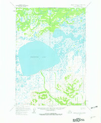
1952 Map of Russian Mission B-3
USGS Topo · Published 1966About this map
Whitefish Lake dominates this 1952 landscape, its expansive waters surrounded by a complex network of marshes, smaller ponds, and meandering drainage systems typical of the Yukon-Kuskokwim Delta region. The map provides a rare look at the area's travel infrastructure before modern aviation took precedence, specifically tracing the Winter Trail as it skirts the southern and eastern shores of the lake. This route likely served as a primary artery for seasonal travel through the wetlands when the ground was frozen. To the north, Discovery Creek and its associated Discovery region indicate early exploration and water-based transit corridors. Higher terrain is marked by peaks like Salat and Fish, which provided critical navigational landmarks for those traversing the low-lying tundra. In the south, the terrain rises toward Ophir near the headwaters of Ophir Creek, illustrating the transition from flat wetlands to more elevated, broken ground.
Find a feature on this map
10 named features on this map. Tap any name to fly to it.
Don’t see what you’re looking for? This feature index may not catch every label — zoom into the map to look around manually.
Map Details
Editions of this 1952 Russian Mission B-3 Map
2 editions found
Other maps of this area

1947 · Russian Mission
USGS Topo · 1:250,000

1950 · Russian Mission
USGS Topo · 1:250,000

1952 · Russian Mission C-3
USGS Topo · 1:63,360

1952 · Russian Mission C-2
USGS Topo · 1:63,360

1952 · Russian Mission B-2
USGS Topo · 1:63,360

1954 · Russian Mission A-4
USGS Topo · 1:63,360

1954 · Russian Mission C-4
USGS Topo · 1:63,360

1954 · Russian Mission B-4
USGS Topo · 1:63,360

1954 · Russian Mission A-3
USGS Topo · 1:63,360

1979 · Russian Mission A-2
USGS Topo · 1:63,360