
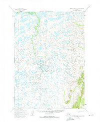
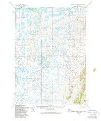
1954 Map of Russian Mission A-4
USGS Topo · Published 1962About this map
Bogus Creek meanders through a landscape of countless unnamed lakes and marshes in this mid-century sub-arctic survey. The terrain transition is marked by the appearance of Mary-Lou Gulch as the land rises out of the wetland flats toward the east. This 1954 environment is defined by its water systems, notably Birch Slough, which dominates the southwestern portion of the sheet. Human transit is limited to a long Winter Trail stretching across the northern reaches, indicating the seasonal nature of movement through this region of Alaska during the early Cold War era. The data reflects a snapshot of an unsurveyed wilderness, with land lines predetermined by the Bureau of Land Management but not yet marked on the ground.
Find a feature on this map
5 named features on this map. Tap any name to fly to it.
Don’t see what you’re looking for? This feature index may not catch every label — zoom into the map to look around manually.
Map Details
Editions of this 1954 Russian Mission A-4 Map
3 editions found
Other maps of this area

1947 · Russian Mission
USGS Topo · 1:250,000

1950 · Russian Mission
USGS Topo · 1:250,000

1950 · Bethel
USGS Topo · 1:250,000

1952 · Russian Mission B-3
USGS Topo · 1:63,360

1954 · Russian Mission B-5
USGS Topo · 1:63,360

1954 · Russian Mission A-5
USGS Topo · 1:63,360

1954 · Russian Mission B-4
USGS Topo · 1:63,360

1954 · Bethel D-4
USGS Topo · 1:63,360

1954 · Bethel D-5
USGS Topo · 1:63,360

1954 · Russian Mission A-3
USGS Topo · 1:63,360