
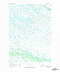
1954 Map of Bethel D-5
USGS Topo · Published 1965About this map
The Kisaralik River and Kasigluk River snake through this corner of the Yukon-Kuskokwim Delta, defining a landscape of saturated wetlands and countless unnamed tundra ponds. Mapped by the Army Map Service using aerial photography from the mid-1950s, the terrain shows the intricate drainage patterns of the Alaskan interior before modern development. In the northeast, the Tuluksak River flows toward the Kuskokwim, while a marked Winter Trail provides a rare terrestrial landmark across the frozen or boggy ground. This survey reflects the complex hydrology of the region, where seasonal water levels dictate travel and subsistence patterns for the local communities.
Find a feature on this map
4 named features on this map. Tap any name to fly to it.
Don’t see what you’re looking for? This feature index may not catch every label — zoom into the map to look around manually.
Map Details
Editions of this 1954 Bethel D-5 Map
2 editions found
Other maps of this area

1947 · Russian Mission
USGS Topo · 1:250,000

1950 · Russian Mission
USGS Topo · 1:250,000

1950 · Bethel
USGS Topo · 1:250,000

1954 · Russian Mission A-4
USGS Topo · 1:63,360

1954 · Russian Mission A-6
USGS Topo · 1:63,360

1954 · Russian Mission A-5
USGS Topo · 1:63,360

1954 · Bethel D-4
USGS Topo · 1:63,360

1954 · Bethel C-6
USGS Topo · 1:63,360

1954 · Bethel C-5
USGS Topo · 1:63,360

1954 · Bethel D-6
USGS Topo · 1:63,360