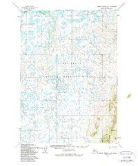
1954 Map of Russian Mission A-4
USGS Topo · Published 1988About this map
Bogus Creek and the meandering channels of Birch Slough define this portion of the Alaskan wilderness, mapped during the mid-1950s. The landscape is characterized by a dense network of small lakes and seasonal watercourses within what is now the Yukon Delta National Wildlife Refuge. This survey, based on aerial photography from 1952 and 1954, reveals the vital importance of the Winter Trail as a primary means of overland movement across the frozen wetlands. On the eastern edge of the quadrangle, the terrain shifts abruptly as the flat marshlands give way to rising ground, marked by features such as Mary Lou Gulch. The map serves as a primary record of the hydrological patterns and early transit corridors in this remote region before later modern developments or shifts in the delta’s drainage.
Find a feature on this map
7 named features on this map. Tap any name to fly to it.
Don’t see what you’re looking for? This feature index may not catch every label — zoom into the map to look around manually.
Map Details
Editions of this 1954 Russian Mission A-4 Map
3 editions found
Other maps of this area

1947 · Russian Mission
USGS Topo · 1:250,000

1950 · Russian Mission
USGS Topo · 1:250,000

1950 · Bethel
USGS Topo · 1:250,000

1952 · Russian Mission B-3
USGS Topo · 1:63,360

1954 · Russian Mission A-4
USGS Topo · 1:63,360

1954 · Russian Mission B-5
USGS Topo · 1:63,360

1954 · Russian Mission A-5
USGS Topo · 1:63,360

1954 · Russian Mission B-4
USGS Topo · 1:63,360

1954 · Bethel D-4
USGS Topo · 1:63,360

1954 · Bethel D-5
USGS Topo · 1:63,360