
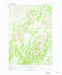
1954 Map of Russian Mission A-3
USGS Topo · Published 1965About this map
Mount Hamilton stands as a prominent landmark in this 1954 survey of the Alaskan interior, located within the Bethel region. The landscape is defined by an intricate network of waterways draining the highlands, most notably the Tuluksak River and its various tributaries. These streams, including Ophir Creek, California Creek, and Bonanza Creek, suggest a history of prospecting and drainage patterns vital to the local geography.
Find a feature on this map
23 named features on this map. Tap any name to fly to it.
Don’t see what you’re looking for? This feature index may not catch every label — zoom into the map to look around manually.
Map Details
Editions of this 1954 Russian Mission A-3 Map
2 editions found
Other maps of this area

1947 · Russian Mission
USGS Topo · 1:250,000

1950 · Russian Mission
USGS Topo · 1:250,000

1950 · Bethel
USGS Topo · 1:250,000

1952 · Russian Mission B-2
USGS Topo · 1:63,360

1952 · Russian Mission B-3
USGS Topo · 1:63,360

1954 · Russian Mission A-4
USGS Topo · 1:63,360

1954 · Russian Mission B-4
USGS Topo · 1:63,360

1954 · Bethel D-4
USGS Topo · 1:63,360

1954 · Bethel D-3
USGS Topo · 1:63,360

1979 · Bethel D-2
USGS Topo · 1:63,360