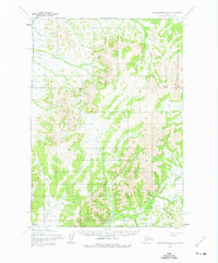
1954 Map of Russian Mission A-3
USGS Topo · Published 1976About this map
The settlement of Nyac serves as the focal point of this mid-century survey, situated in a remote interior landscape defined by the drainage systems of the Tuluksak River. The map captures the region's topographical complexity, dominated by Mount Hamilton and the strategic Rockpile Pass. A dense network of gold-rush era watercourses like Bonanza Creek, Shamrock Creek, and East Fork Bear Creek suggests a history of prospecting, further evidenced by colorfully named drainages such as Mary Lou Gulch and Happy Gulch. The presence of Hot Spring Creek indicates the geothermal activity characteristic of this part of the Alaskan wilderness. This survey, compiled from aerial photography taken in the early 1950s, documents the intricate relationship between the braided river valleys and the high ridges before modern infrastructure altered the terrain. It remains a critical record for understanding the mining geography and hydraulic systems of the Dugout Creek and Shovel Creek area.
Find a feature on this map
23 named features on this map. Tap any name to fly to it.
Don’t see what you’re looking for? This feature index may not catch every label — zoom into the map to look around manually.
Map Details
Editions of this 1954 Russian Mission A-3 Map
2 editions found
Other maps of this area

1947 · Russian Mission
USGS Topo · 1:250,000

1950 · Russian Mission
USGS Topo · 1:250,000

1950 · Bethel
USGS Topo · 1:250,000

1952 · Russian Mission B-2
USGS Topo · 1:63,360

1952 · Russian Mission B-3
USGS Topo · 1:63,360

1954 · Russian Mission A-4
USGS Topo · 1:63,360

1954 · Russian Mission B-4
USGS Topo · 1:63,360

1954 · Bethel D-4
USGS Topo · 1:63,360

1954 · Russian Mission A-3
USGS Topo · 1:63,360

1954 · Bethel D-3
USGS Topo · 1:63,360