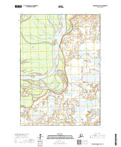
2017 Map of Russian Mission B-5 SE
USGS Topo · Published 2017About this map
Kuskokwim River dominates this portion of the Bethel Census Area, winding through a complex system of active channels and side sloughs. The landscape is defined by the fluid nature of this major waterway, where the shifting current carves through the alluvial plain, creating numerous islands and gravel bars. Public land divisions across the area are organized within t15n r64w, t15n r63w, t14n r64w, and t14n r63w, reflecting the formal mapping of this remote river corridor. Away from the main channel, the terrain is characterized by extensive wetlands and small, unnamed tundra lakes, illustrating the low-lying and saturated nature of the Alaskan interior in this region. This survey captures the braided character of the river system before further natural migration of its banks, providing a reference for the topographic state of the valley in the early twenty-first century.
Find a feature on this map
7 named features on this map. Tap any name to fly to it.
Don’t see what you’re looking for? This feature index may not catch every label — zoom into the map to look around manually.
Map Details
Editions of this 2017 Russian Mission B-5 SE Map
This is the sole edition of this map. No revisions or reprints were ever made.
Other maps of this area

1947 · Russian Mission
USGS Topo · 1:250,000

1950 · Russian Mission
USGS Topo · 1:250,000

1954 · Russian Mission A-4
USGS Topo · 1:63,360

1954 · Russian Mission B-5
USGS Topo · 1:63,360

1954 · Russian Mission A-5
USGS Topo · 1:63,360

1954 · Russian Mission B-4
USGS Topo · 1:63,360

1980 · Russian Mission
USGS Topo · 1:250,000
2017 · Russian Mission A-5 NW
USGS Topo · 1:25,000
2017 · Russian Mission A-4 NW
USGS Topo · 1:25,000
2017 · Russian Mission B-5 NW
USGS Topo · 1:25,000