
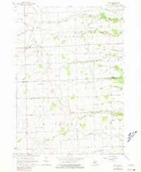
1963 Map of Ruth
USGS Topo · Published 1964About this map
The settlement of Ruth stands as a primary hub in this agricultural landscape of the early 1960s, situated along the Chesapeake and Ohio railroad line. The map captures a detailed transition between Sherman and Delaware townships, where the local economy is anchored by small rural schools like Sherman Sch and Kelly Sch. The terrain is defined by a dense network of drainage systems and creeks, including White River, Mill Creek, and Slatestone Creek, which carve through the farmland.
Find a feature on this map
39 named features on this map. Tap any name to fly to it.
Don’t see what you’re looking for? This feature index may not catch every label — zoom into the map to look around manually.
Map Details
Editions of this 1963 Ruth Map
2 editions found
Other maps of this area

1954 · Flint
USGS Topo · 1:250,000

1958 · Flint
USGS Topo · 1:250,000

1963 · Forestville
USGS Topo · 1:24,000

1963 · Minden City
USGS Topo · 1:24,000

1963 · Palms
USGS Topo · 1:24,000

1963 · Deckerville
USGS Topo · 1:24,000

1963 · Richmondville
USGS Topo · 1:24,000

1970 · Harbor Beach
USGS Topo · 1:24,000

1970 · Bad Axe SE
USGS Topo · 1:24,000

1984 · Harbor Beach
USGS Topo · 1:100,000