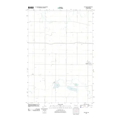
2011 Map of Rutland
USGS Topo · Published 2011About this map
Rutland is the primary settlement on this North Dakota prairie landscape, situated along a network of numbered section roads and local ways like Front St and Cooper St. The town serves as a hub for the surrounding agricultural area, which is defined by a series of significant water bodies to the south and west. Silver Lake is a prominent feature, managed by the Silver Lake Dam, while the Wild Rice River meanders across the southern portion of the quadrangle. Other notable water features include Sprague Lake, Lake Mann, and the northern reaches of Crooked Creek.
Find a feature on this map
30 named features on this map. Tap any name to fly to it.
Don’t see what you’re looking for? This feature index may not catch every label — zoom into the map to look around manually.
Map Details
Editions of this 2011 Rutland Map
This is the sole edition of this map. No revisions or reprints were ever made.
Other maps of this area

1907 · Wyndmere
USGS Topo · 1:125,000

1953 · Kidder
USGS Topo · 1:24,000

1953 · Milbank
USGS Topo · 1:250,000

1953 · Fargo
USGS Topo · 1:250,000

1956 · Fargo
USGS Topo · 1:250,000

1956 · Havana
USGS Topo · 1:24,000

1958 · Milbank
USGS Topo · 1:250,000

1958 · Marlow
USGS Topo · 1:24,000

1958 · Rutland
USGS Topo · 1:24,000
1958 · Forman
USGS Topo · 1:24,000