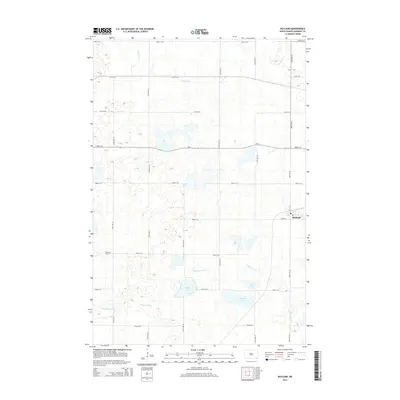
2014 Map of Rutland
USGS Topo · Published 2014About this map
The town of Rutland anchors the eastern edge of this Sargent County landscape, serving as a focal point for a region defined by its complex hydrography and agricultural grid. The meandering path of the Wild Rice River cuts through the southern portion of the quadrangle, surrounded by several prominent water bodies including Silver Lake, Sprague Lake, and Lake Mann. These wetlands and lakes are characteristic of the drift prairie, where drainage patterns are often subtle and non-integrated. To the north, the headwaters of Crooked Cr wind through the section lines. For local historians and genealogists, the inclusion of Trinity Cem in the southwest provides a specific point of interest for family research. The map also documents the primary transit corridor of ND-11, which connects the small settlement of Rutland to the surrounding rural sections.
Find a feature on this map
26 named features on this map. Tap any name to fly to it.
Don’t see what you’re looking for? This feature index may not catch every label — zoom into the map to look around manually.
Map Details
Editions of this 2014 Rutland Map
This is the sole edition of this map. No revisions or reprints were ever made.
Other maps of this area

1907 · Wyndmere
USGS Topo · 1:125,000

1953 · Kidder
USGS Topo · 1:24,000

1953 · Milbank
USGS Topo · 1:250,000

1953 · Fargo
USGS Topo · 1:250,000

1956 · Fargo
USGS Topo · 1:250,000

1956 · Havana
USGS Topo · 1:24,000

1958 · Milbank
USGS Topo · 1:250,000

1958 · Marlow
USGS Topo · 1:24,000

1958 · Rutland
USGS Topo · 1:24,000
1958 · Forman
USGS Topo · 1:24,000