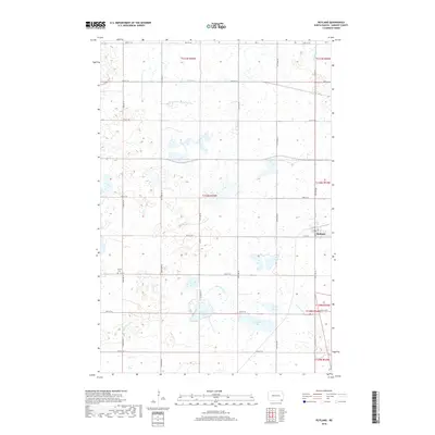
2018 Map of Rutland
USGS Topo · Published 2018About this map
Rutland stands as the primary hub of this prairie landscape in Sargent County, situated at the intersection of a grid of local roads and the regional corridor of Co Rd 3. The terrain is defined by a complex network of wetlands and water bodies, most notably the meandering course of the Wild Rice River in the south and Crooked Cr to the north. These waterways feed into several distinct basins, including Silver Lake, Sprague Lake, and Lake Mann, which break up the agricultural rhythm of the section lines. This 2018 survey reveals a rural landscape where history is preserved in sites like Trinity Cem, located west of the main settlement. The map illustrates how modern property boundaries and section roads like 96th St SE follow the legacy of the Public Land Survey System across the North Dakota plains.
Find a feature on this map
21 named features on this map. Tap any name to fly to it.
Don’t see what you’re looking for? This feature index may not catch every label — zoom into the map to look around manually.
Map Details
Editions of this 2018 Rutland Map
This is the sole edition of this map. No revisions or reprints were ever made.
Other maps of this area

1907 · Wyndmere
USGS Topo · 1:125,000

1953 · Kidder
USGS Topo · 1:24,000

1953 · Milbank
USGS Topo · 1:250,000

1953 · Fargo
USGS Topo · 1:250,000

1956 · Fargo
USGS Topo · 1:250,000

1956 · Havana
USGS Topo · 1:24,000

1958 · Milbank
USGS Topo · 1:250,000

1958 · Marlow
USGS Topo · 1:24,000

1958 · Rutland
USGS Topo · 1:24,000
1958 · Forman
USGS Topo · 1:24,000