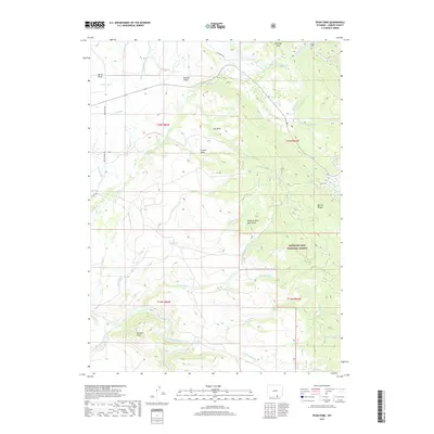
2017 Map of Ryan Park
USGS Topo · Published 2017About this map
Medicine Bow National Forest encompasses much of this terrain within the Medicine Bow Mountains, where rugged peaks and vital water management systems define the landscape. The small settlement of Ryan Park is positioned near the eastern edge, while the southwest is dominated by the prominent Bennett Peak. The land is intricately carved by numerous drainages, including Brush Cr and Beaver Cr, which feed into the winding North Platte River at the southern boundary. This 2017 survey highlights a complex network of ranching and irrigation infrastructure, evidenced by the Wiant Ditch, Cook Ditch, and Stewart Ditch. These human-made channels, alongside named geographical features like Barrett Ridge and Francis Draw, illustrate how the natural topography has been utilized for water diversion and land management in Carbon County.
Find a feature on this map
33 named features on this map. Tap any name to fly to it.
Don’t see what you’re looking for? This feature index may not catch every label — zoom into the map to look around manually.
Map Details
Editions of this 2017 Ryan Park Map
This is the sole edition of this map. No revisions or reprints were ever made.
Other maps of this area

1906 · Medicine Bow
USGS Topo · 1:125,000

1908 · Medicine Bow
USGS Topo · 1:125,000

1939 · Saratoga
USGS Topo · 1:125,000

1954 · Rawlins
USGS Topo · 1:250,000

1958 · Rawlins
USGS Topo · 1:250,000

1961 · Overlook Hill
USGS Topo · 1:24,000

1961 · Ryan Park
USGS Topo · 1:24,000
1961 · Kennaday Peak
USGS Topo · 1:24,000
1961 · Finley Reservoir
USGS Topo · 1:24,000

1961 · Gunst Reservoir
USGS Topo · 1:24,000