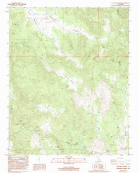
1986 Map of Sacatar Canyon
USGS Topo · Published 1994About this map
Kennedy Meadows serves as a primary hub for this high-altitude landscape in the southern Sierras during the mid-1980s. The map details a complex network of seasonal drainages and meadows, including Sacatar Meadow, Big Pine Meadow, and Johnson Meadow, which define the local geography. Human activity is marked by the presence of a Fire Sta, a Landfill, and the remote Sacatar Airstrip near the Inyo and Tulare county line. The Pacific Crest National Scenic Trail traverses the eastern ridges, providing a corridor for backcountry travel. Evidence of resource extraction appears in the south with an Open Pit Mine and various Prospect locations, while the topography is dominated by peaks like Kennedy Peak and deep cuts like Sacatar Canyon.
Find a feature on this map
26 named features on this map. Tap any name to fly to it.
Don’t see what you’re looking for? This feature index may not catch every label — zoom into the map to look around manually.
Map Details
Editions of this 1986 Sacatar Canyon Map
2 editions found
Other maps of this area

1905 · Olancha
USGS Topo · 1:125,000

1906 · Kernville
USGS Topo · 1:125,000

1907 · Olancha
USGS Topo · 1:125,000

1908 · Kernville
USGS Topo · 1:125,000

1908 · Ballarat
USGS Topo · 1:250,000

1913 · Ballarat
USGS Topo · 1:250,000

1915 · Searles Lake
USGS Topo · 1:250,000

1947 · Trona
USGS Topo · 1:250,000

1948 · Trona
USGS Topo · 1:250,000

1948 · Death Valley
USGS Topo · 1:250,000