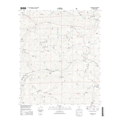
2013 Map of Sacramento
USGS Topo · Published 2013About this map
The Sacramento Mountains dominate this high-elevation terrain within the Lincoln National Forest, where the remote communities of Sacramento, Weed, and Mayhill are connected by winding mountain roads. The drainage pattern of the Rio Peñasco and Agua Chiquita Creek dictates the placement of settlements, which are often found where canyons widen or water remains accessible. Cultural landmarks such as the Weed Cemetery, a post office, and the Weed Lookout tower indicate a well-established but sparsely populated mountain society. Numerous livestock tanks and springs, including Bear Canyon Lake, McEwan Lake, and Curtis Canyon Dam, are scattered throughout the draws and canyons like Wills Canyon, Cox Canyon, and Pendleton Canyon, highlighting the importance of water management for ranching in this arid upland environment.
Find a feature on this map
80 named features on this map. Tap any name to fly to it.
Don’t see what you’re looking for? This feature index may not catch every label — zoom into the map to look around manually.
Map Details
Editions of this 2013 Sacramento Map
This is the sole edition of this map. No revisions or reprints were ever made.
Other maps of this area

1952 · Cloudcroft
USGS Topo · 1:62,500

1954 · Carlsbad
USGS Topo · 1:250,000

1958 · Carlsbad
USGS Topo · 1:250,000

1963 · Mayhill
USGS Topo · 1:24,000

1963 · Woodson Canyon
USGS Topo · 1:24,000

1965 · Bear Spring
USGS Topo · 1:24,000

1965 · Avis
USGS Topo · 1:24,000

1965 · Rogers Ruins
USGS Topo · 1:24,000
1974 · Sacramento
USGS Topo · 1:24,000
1974 · Bluff Springs
USGS Topo · 1:24,000