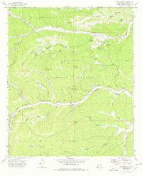
1974 Map of Sacramento
USGS Topo · Published 1978About this map
Sacramento and Weed serve as the primary hubs in this mid-1970s survey of the Otero County highlands. The landscape is defined by the canyon systems of Agua Chiquita Creek and Rio Peñasco, where water sources like Peñasco Springs and Long Spring supported early settlement and ranching. Within the Lincoln National Forest, a network of recreation sites and forest infrastructure is visible, including Sivells Camp, Camp Mary White, and Camp Tall Pines.
Find a feature on this map
51 named features on this map. Tap any name to fly to it.
Don’t see what you’re looking for? This feature index may not catch every label — zoom into the map to look around manually.
Map Details
Editions of this 1974 Sacramento Map
This is the sole edition of this map. No revisions or reprints were ever made.
Other maps of this area

1952 · Cloudcroft
USGS Topo · 1:62,500

1954 · Carlsbad
USGS Topo · 1:250,000

1958 · Carlsbad
USGS Topo · 1:250,000

1963 · Mayhill
USGS Topo · 1:24,000

1963 · Woodson Canyon
USGS Topo · 1:24,000

1965 · Bear Spring
USGS Topo · 1:24,000

1965 · Avis
USGS Topo · 1:24,000

1965 · Rogers Ruins
USGS Topo · 1:24,000
1974 · Bluff Springs
USGS Topo · 1:24,000
1974 · Harvey Ranch
USGS Topo · 1:24,000