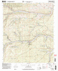
2004 Map of Sacramento
USGS Topo · Published 2006About this map
Sacramento serves as a central hub within the Lincoln National Forest, defined by its complex network of canyons and upland springs. The landscape at the start of the 21st century reflects a long history of institutional presence, with the Sacramento Methodist Assembly, Sivells Baptist Camp, and Camp Mary White occupying strategic positions near reliable water sources like the Rio Peñasco. This period shows the region's transition from a strictly resource-based mountain economy toward recreation and administrative stewardship, evidenced by the Sacramento Admin Site and the high-elevation Weed Lookout.
Find a feature on this map
82 named features on this map. Tap any name to fly to it.
Don’t see what you’re looking for? This feature index may not catch every label — zoom into the map to look around manually.
Map Details
Editions of this 2004 Sacramento Map
This is the sole edition of this map. No revisions or reprints were ever made.
Other maps of this area

1952 · Cloudcroft
USGS Topo · 1:62,500

1954 · Carlsbad
USGS Topo · 1:250,000

1958 · Carlsbad
USGS Topo · 1:250,000

1963 · Mayhill
USGS Topo · 1:24,000

1963 · Woodson Canyon
USGS Topo · 1:24,000

1965 · Bear Spring
USGS Topo · 1:24,000

1965 · Avis
USGS Topo · 1:24,000

1965 · Rogers Ruins
USGS Topo · 1:24,000
1974 · Sacramento
USGS Topo · 1:24,000
1974 · Bluff Springs
USGS Topo · 1:24,000