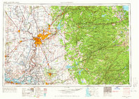
1957 Map of Sacramento
USGS Topo · Published 1966About this map
The Sacramento River and its major tributaries, including the American River and Feather River, anchor this detailed mid-century survey of California’s Central Valley and the rising Sierra Nevada. During this era of post-war expansion, the region saw significant suburban growth in communities like Carmichael, North Highlands, and Roseville, while established agricultural centers such as Woodland and Lodi remained central to the valley's economy. The map captures the complex water management systems of the day, showing the Sutter Basin and Yolo Bypass alongside newer landmarks like Folsom Lake.
Find a feature on this map
261 named features on this map. Tap any name to fly to it.
Don’t see what you’re looking for? This feature index may not catch every label — zoom into the map to look around manually.
Map Details
Editions of this 1957 Sacramento Map
4 editions found
Other maps of this area

1888 · Marysville
USGS Topo · 1:125,000

1888 · Smartsville
USGS Topo · 1:125,000

1889 · Jackson
USGS Topo · 1:125,000

1889 · Pyramid Peak
USGS Topo · 1:125,000

1889 · Markleeville
USGS Topo · 1:125,000

1891 · Sacramento
USGS Topo · 1:125,000

1891 · Carson
USGS Topo · 1:125,000

1891 · Markleeville
USGS Topo · 1:125,000

1891 · Colfax
USGS Topo · 1:125,000

1891 · Truckee
USGS Topo · 1:125,000