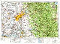
1957 Map of Sacramento
USGS Topo · Published 1972About this map
Sacramento stands as the central hub of this mid-century survey, surrounded by its burgeoning suburbs and the expanding footprints of McClellan Air Force Base and Mather Air Force Base. The map captures the transition from the agricultural expanses of the Sacramento Valley to the high peaks of the Sierra Nevada. To the east, the historic Mother Lode mining district is well-represented, featuring legendary sites like the Argonaut Mine and Kennedy Mine near Jackson, along with the Marshall Gold Discovery State Historical Monument at Coloma.
Find a feature on this map
419 named features on this map. Tap any name to fly to it.
Don’t see what you’re looking for? This feature index may not catch every label — zoom into the map to look around manually.
Map Details
Editions of this 1957 Sacramento Map
4 editions found
Other maps of this area

1888 · Marysville
USGS Topo · 1:125,000

1888 · Smartsville
USGS Topo · 1:125,000

1889 · Jackson
USGS Topo · 1:125,000

1889 · Pyramid Peak
USGS Topo · 1:125,000

1889 · Markleeville
USGS Topo · 1:125,000

1891 · Sacramento
USGS Topo · 1:125,000

1891 · Carson
USGS Topo · 1:125,000

1891 · Markleeville
USGS Topo · 1:125,000

1891 · Colfax
USGS Topo · 1:125,000

1891 · Truckee
USGS Topo · 1:125,000