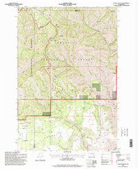
1995 Map of Saddle Butte
USGS Topo · Published 1998About this map
Umatilla National Forest defines this high-elevation landscape along the Garfield and Asotin county line during the mid-1990s. The map illustrates a transition from the dense drainage networks of Menatchee Creek and Grouse Creek to the broader plateaus of Grouse Flat in the south. Notable for its administrative and ranching history, the sheet identifies the Wenatchee Guard Station in the northeast corner and the H A McEachan Ranch further south, providing a record of land use before modern developments. The topography is punctuated by stark peaks like Mount Horrible and Saddle Butte, while the Grouse Flat Wildlife Area highlights the region's conservation focus. Numerous remote water sources, including Rimfire Spring and Bucher Spring, appear alongside old forest routes like the West Menatchee Trail and Pomeroy Road.
Find a feature on this map
88 named features on this map. Tap any name to fly to it.
Don’t see what you’re looking for? This feature index may not catch every label — zoom into the map to look around manually.
Map Details
Editions of this 1995 Saddle Butte Map
This is the sole edition of this map. No revisions or reprints were ever made.
Other maps of this area

1937 · Pomeroy
USGS Topo · 1:96,000

1942 · Pomeroy
USGS Topo · 1:125,000

1943 · Saddle Butte
USGS Topo · 1:62,500

1946 · Saddle Butte
USGS Topo · 1:62,500

1955 · Pullman
USGS Topo · 1:250,000

1955 · Grangeville
USGS Topo · 1:250,000

1958 · Pullman
USGS Topo · 1:250,000

1959 · Grangeville
USGS Topo · 1:250,000

1967 · Troy
USGS Topo · 1:24,000

1967 · Eden
USGS Topo · 1:24,000