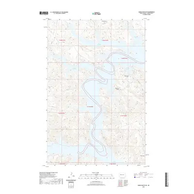
2020 Map of Saddle Butte SW
USGS Topo · Published 2020About this map
Lake Sakakawea dominates this landscape in the Missouri River basin, creating a jagged shoreline defined by numerous arms and inlets. The complex hydrology of the reservoir is visible through deeply recessed features like Charging Eagle Bay and Moccasin Creek Bay, which reach far into the surrounding high ground. The terrain is characterized by traditional Great Plains landforms, including the prominent String Buttes to the north and various drainage channels such as Ash Coulee and Sagebrush Coulee. This 2020 survey illustrates the modern configuration of the Fort Berthold area, where Bureau of Indian Affairs routes like Bia RD 17 and Bia Rte 223 provide the primary access through the broken topography of Dunn County.
Find a feature on this map
20 named features on this map. Tap any name to fly to it.
Don’t see what you’re looking for? This feature index may not catch every label — zoom into the map to look around manually.
Map Details
Editions of this 2020 Saddle Butte SW Map
This is the sole edition of this map. No revisions or reprints were ever made.
Other maps of this area

1953 · Watford City
USGS Topo · 1:250,000

1957 · Watford City
USGS Topo · 1:250,000

1967 · Watford City
USGS Topo · 1:250,000

1970 · Halliday NE
USGS Topo · 1:24,000

1970 · Hay Flat
USGS Topo · 1:24,000

1970 · String Buttes
USGS Topo · 1:24,000

1970 · Halliday NW
USGS Topo · 1:24,000
1970 · Saddle Butte
USGS Topo · 1:24,000

1970 · Dunn Center NE
USGS Topo · 1:24,000

1970 · Mandaree SE
USGS Topo · 1:24,000