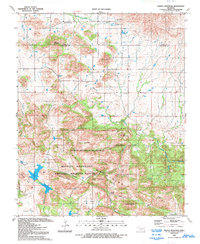
1991 Map of Saddle Mountain
USGS Topo · Published 1993About this map
Wichita Mountains National Wildlife Refuge dominates the southern half of this landscape, encompassing a complex terrain of ridges and valleys in the heart of the Wichita Mountains. The topography transitions from the high peaks of North Mountain and Pearl Mountain down into the protected expanse of the North Mountain Wilderness. Water is a defining element for both wildlife and history here, with named sources like Hourigan Spring and Black Bear Spring feeding into Medicine Creek and Sugar Creek. Near the northern boundary between Kiowa and Comanche counties, the settlement of Saddle Mountain sits near its namesake peak and the Saddle Mountain Cem. The presence of several small reservoirs, including Grama Lake, Kiowa Lake, and Comanche Lake, highlights the managed water resources of the wildlife refuge during the late twentieth century.
Find a feature on this map
37 named features on this map. Tap any name to fly to it.
Don’t see what you’re looking for? This feature index may not catch every label — zoom into the map to look around manually.
Map Details
Editions of this 1991 Saddle Mountain Map
2 editions found
Other maps of this area

1937 · Cache
USGS Topo · 1:48,000

1937 · Quanah Mountain
USGS Topo · 1:24,000

1942 · Cache
USGS Topo · 1:62,500

1949 · Mount Scott
USGS Topo · 1:24,000

1949 · Cooperton
USGS Topo · 1:62,500

1949 · Quanah Mountain
USGS Topo · 1:24,000

1950 · Snyder
USGS Topo · 1:62,500

1950 · Saddle Mountain
USGS Topo · 1:62,500

1955 · Lawton
USGS Topo · 1:250,000

1956 · Saddle Mountain
USGS Topo · 1:24,000