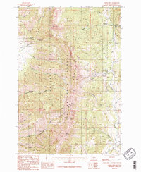
1987 Map of Saddle Peak
USGS Topo · Published 1987About this map
Gallatin National Forest dominates this 1980s topography, anchored by the high ridgelines of the Bridger Range. The landscape is defined by its dramatic relief, with prominent summits like Ross Peak and Saddle Peak overlooking a complex network of drainage basins. To the east, the Bridger Bowl Ski Area marks a significant recreational development on the mountain slopes, while the northern reaches provide public access through the Brackett Creek Campground. Numerous gulches and canyons, such as Limestone Canyon and Bostwick Canyon, carve through the terrain, feeding into water systems like Bridger Creek and Ross Creek. Smaller landmarks, including the Spring Hill Pavilion, suggest local gathering points amidst the timbered slopes and high alpine passes like Ross Pass. The map captures the area as a vital nexus of outdoor recreation and natural resource management in Gallatin County.
Find a feature on this map
32 named features on this map. Tap any name to fly to it.
Don’t see what you’re looking for? This feature index may not catch every label — zoom into the map to look around manually.
Map Details
Editions of this 1987 Saddle Peak Map
2 editions found
Other maps of this area

1888 · Three Forks
USGS Topo · 1:250,000

1891 · Livingston
USGS Topo · 1:250,000

1893 · Livingston
USGS Topo · 1:250,000

1894 · Three Forks
USGS Topo · 1:250,000

1895 · Three Forks
USGS Topo · 1:250,000

1947 · Bozeman
USGS Topo · 1:250,000

1948 · Bozeman
USGS Topo · 1:250,000

1950 · Belgrade
USGS Topo · 1:62,500

1951 · Bozeman Pass
USGS Topo · 1:62,500

1951 · Sedan
USGS Topo · 1:62,500