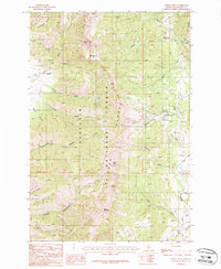
1987 Map of Saddle Peak
USGS Topo · Published 1987About this map
Ross Peak and Saddle Peak dominate this high-elevation segment of the Gallatin National Forest, where the complex drainage systems of the Bridger Range are mapped in detail. The topography is defined by sharp canyons such as Bostwick Canyon and Limestone Canyon, alongside high passes like Ross Pass. These natural features dictated the early recreational and resource development of the area, most notably seen in the established Bridger Bowl Ski Area and the isolated Spring Hill Pavilion to the west.
Find a feature on this map
33 named features on this map. Tap any name to fly to it.
Don’t see what you’re looking for? This feature index may not catch every label — zoom into the map to look around manually.
Map Details
Editions of this 1987 Saddle Peak Map
2 editions found
Other maps of this area

1888 · Three Forks
USGS Topo · 1:250,000

1891 · Livingston
USGS Topo · 1:250,000

1893 · Livingston
USGS Topo · 1:250,000

1894 · Three Forks
USGS Topo · 1:250,000

1895 · Three Forks
USGS Topo · 1:250,000

1947 · Bozeman
USGS Topo · 1:250,000

1948 · Bozeman
USGS Topo · 1:250,000

1950 · Belgrade
USGS Topo · 1:62,500

1951 · Bozeman Pass
USGS Topo · 1:62,500

1951 · Sedan
USGS Topo · 1:62,500