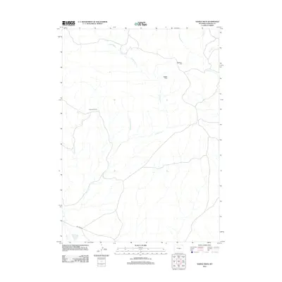
2012 Map of Saddle Rock
USGS Topo · Published 2012About this map
Cottonwood Ranch and the distinctive formation of Saddle Rock characterize this remote landscape in Natrona County. The terrain is defined by a dendritic network of seasonal drainages, where Cottonwood Cr and its tributary Little Cottonwood Cr cut through the high plains. Further east, the topographic rise of Sagehen Hill overlooks the confluence areas of Poison Spider Cr and Peach Cr. This 2012 survey illustrates the sparse human footprint in this part of Wyoming, where infrastructure is limited to ranching outposts and a few named thoroughfares like Dry Creek Rd. The presence of numerous named watercourses, including Horse Cr and Chokecherry Cr, highlights the critical role of surface hydrology in the management and organization of this rangeland.
Find a feature on this map
12 named features on this map. Tap any name to fly to it.
Don’t see what you’re looking for? This feature index may not catch every label — zoom into the map to look around manually.
Map Details
Editions of this 2012 Saddle Rock Map
This is the sole edition of this map. No revisions or reprints were ever made.
Other maps of this area

1955 · Casper
USGS Topo · 1:250,000

1958 · Casper
USGS Topo · 1:250,000

1959 · Eightmile Draw
USGS Topo · 1:24,000

1959 · Horse Creek Springs
USGS Topo · 1:24,000

1959 · Sanford Ranch
USGS Topo · 1:24,000
1959 · Stinking Water Creek
USGS Topo · 1:24,000

1959 · Saddle Rock
USGS Topo · 1:24,000

1959 · Miller Spring
USGS Topo · 1:24,000

1959 · Barlow Gap
USGS Topo · 1:24,000
1959 · Garfield Peak
USGS Topo · 1:24,000