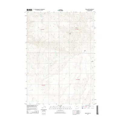
2015 Map of Saddle Rock
USGS Topo · Published 2015About this map
Saddle Rock and Sagehen Hill dominate the topography of this high-country landscape in Natrona County. The drainage network is particularly dense, defined by the seasonal flow of Cottonwood Cr and its smaller tributaries like Peach Cr and Soap Cr. The presence of the Cabin Creek Reservoir in the northwest corner suggests the essential role of water management in this arid environment, providing a focal point for the surrounding watershed. This 2015 survey reveals a land primarily shaped by its hydrology and terrain, where landmarks like Roberts Draw and Black Rock Draw serve as the primary navigational features across the open range. The map illustrates how public land survey boundaries and sections organize the territory into manageable blocks, even in areas where human settlement remains sparse and centered on water resources.
Find a feature on this map
17 named features on this map. Tap any name to fly to it.
Don’t see what you’re looking for? This feature index may not catch every label — zoom into the map to look around manually.
Map Details
Editions of this 2015 Saddle Rock Map
This is the sole edition of this map. No revisions or reprints were ever made.
Other maps of this area

1955 · Casper
USGS Topo · 1:250,000

1958 · Casper
USGS Topo · 1:250,000

1959 · Eightmile Draw
USGS Topo · 1:24,000

1959 · Horse Creek Springs
USGS Topo · 1:24,000

1959 · Sanford Ranch
USGS Topo · 1:24,000
1959 · Stinking Water Creek
USGS Topo · 1:24,000

1959 · Saddle Rock
USGS Topo · 1:24,000

1959 · Miller Spring
USGS Topo · 1:24,000

1959 · Barlow Gap
USGS Topo · 1:24,000
1959 · Garfield Peak
USGS Topo · 1:24,000