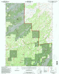
1992 Map of Saddleback Mtn
USGS Topo · Published 1996About this map
Medicine Bow National Forest dominates this high-altitude landscape along the border of Converse and Albany counties. The terrain is defined by a series of prominent peaks and passes that served as natural navigation points for early travelers, including Saddleback Mountain, North Sawtooth Mountain, and Jenkins Pass. The drainage network is complex, with La Bonte Creek and its many tributaries like West Fork La Bonte Creek and Joe Creek carving deep canyons through the rock.
Find a feature on this map
33 named features on this map. Tap any name to fly to it.
Don’t see what you’re looking for? This feature index may not catch every label — zoom into the map to look around manually.
Map Details
Editions of this 1992 Saddleback Mtn Map
2 editions found
Other maps of this area

1943 · Esterbrook
USGS Topo · 1:62,500

1945 · Esterbrook
USGS Topo · 1:62,500

1949 · Poison Lake
USGS Topo · 1:24,000

1950 · Poison Lake
USGS Topo · 1:24,000

1954 · Torrington
USGS Topo · 1:250,000

1958 · Torrington
USGS Topo · 1:250,000

1964 · Toltec
USGS Topo · 1:24,000

1964 · School Section Mountain
USGS Topo · 1:24,000
1964 · Maneater Creek
USGS Topo · 1:24,000
1964 · Blue Nose Creek
USGS Topo · 1:24,000