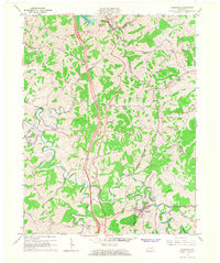
1965 Map of Sadieville
USGS Topo · Published 1966About this map
The Southern Railway follows the winding path of Eagle Creek through the heart of this North Central Kentucky landscape, anchoring the town of Sadieville. This mid-century revision captures a transition in regional transportation as the newly constructed Interstate 75 cuts a massive north-south corridor across the rolling hills, bypassing older settlements like Stonewall and Hinton. The map documents a dense network of local landmarks essential for genealogical research, including Zion Hill Ch, Rays Fork Ch, and several family burial grounds such as Ecklers Cem and Nelson Cem. The intersection of Grant, Harrison, Owen, and Scott counties creates a complex series of political boundaries that converge near Corinth. Smaller watercourses like Mile Creek and Rays Fork define the deeply etched topography, illustrating the traditional settlement patterns that preceded the interstate era.
Find a feature on this map
46 named features on this map. Tap any name to fly to it.
Don’t see what you’re looking for? This feature index may not catch every label — zoom into the map to look around manually.
Map Details
Editions of this 1965 Sadieville Map
2 editions found
Other maps of this area

1929 · Cynthiana
USGS Topo · 1:48,000

1930 · Falmouth
USGS Topo · 1:48,000

1934 · Cynthiana
USGS Topo · 1:62,500

1936 · Falmouth
USGS Topo · 1:62,500

1939 · Sadieville
USGS Topo · 1:62,500

1950 · Mason
USGS Topo · 1:24,000

1950 · Lawrenceville
USGS Topo · 1:24,000

1953 · Sadieville
USGS Topo · 1:24,000

1953 · Berry
USGS Topo · 1:24,000

1953 · Breckinridge
USGS Topo · 1:24,000