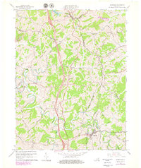
1965 Map of Sadieville
USGS Topo · Published 1979About this map
Sadieville serves as a focal point in this portion of the Kentucky Bluegrass, situated where the Southern railroad line follows the winding valley of Eagle Creek. This 1965 survey, updated with 1970s photorevisions, reveals a landscape defined by sharp ridges and deep creek hollows, with small settlements like Hinton and Stonewall perched along the high ground. The rail corridor is a primary artery for the region, accompanied by a Gaging Station and Water Tank near the tracks in Sadieville.
Find a feature on this map
57 named features on this map. Tap any name to fly to it.
Don’t see what you’re looking for? This feature index may not catch every label — zoom into the map to look around manually.
Map Details
Editions of this 1965 Sadieville Map
2 editions found
Other maps of this area

1929 · Cynthiana
USGS Topo · 1:48,000

1930 · Falmouth
USGS Topo · 1:48,000

1934 · Cynthiana
USGS Topo · 1:62,500

1936 · Falmouth
USGS Topo · 1:62,500

1939 · Sadieville
USGS Topo · 1:62,500

1950 · Mason
USGS Topo · 1:24,000

1950 · Lawrenceville
USGS Topo · 1:24,000

1953 · Sadieville
USGS Topo · 1:24,000

1953 · Berry
USGS Topo · 1:24,000

1953 · Breckinridge
USGS Topo · 1:24,000