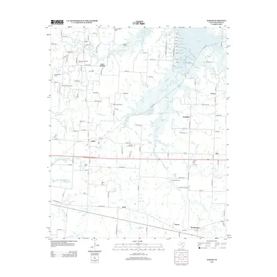
2013 Map of Sadler
USGS Topo · Published 2013About this map
Lake Texoma dominates the northern reaches of this north Texas landscape, where the waters of the Big Mineral Cr and Sandy Cr feed into the reservoir's southern arms. The area is defined by a dense network of energy extraction and local aviation, with several small landing strips like Graham Field Airport and Bevoni-Flying B Airport interspersed among active petroleum operations. Significant energy sites including the Sadler-Moulder Mineral Oil Field and Hudgins Oil Field are visible alongside numerous drilling pads near the shoreline. Settlements like Sadler, Basin Springs, and Southmayd anchor the southern half of the quadrangle. For genealogists, the map identifies key burial sites such as Basin Springs Cem, Sadler Cem, and the Christian Chapel Cem, which reflect the community's early foundations before the modern expansion of the oil industry and the reservoir.
Find a feature on this map
111 named features on this map. Tap any name to fly to it.
Don’t see what you’re looking for? This feature index may not catch every label — zoom into the map to look around manually.
Map Details
Editions of this 2013 Sadler Map
This is the sole edition of this map. No revisions or reprints were ever made.
Other maps of this area

1901 · Denison
USGS Topo · 1:125,000

1954 · Sherman
USGS Topo · 1:250,000

1958 · Dorchester
USGS Topo · 1:24,000

1958 · Gordonville
USGS Topo · 1:62,500

1958 · Denison Dam
USGS Topo · 1:62,500

1958 · Sherman NW
USGS Topo · 1:24,000

1958 · Whitesboro
USGS Topo · 1:62,500

1958 · Sherman
USGS Topo · 1:250,000

1958 · Sherman
USGS Topo · 1:62,500
1976 · Gordonville SE
USGS Topo · 1:24,000