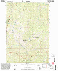
2004 Map of Safety Creek
USGS Topo · Published 2007About this map
Venable Mine and Sunnyside Mine anchor the western edge of this backcountry Idaho landscape, indicating the historical mineral extraction that shaped local development. The map reveals a rugged interior where the Payette National Forest and Boise National Forest meet within the vast Frank Church - River of No Return Wilderness. Near the center of the sheet, the ghost of earlier habitation persists at Belleco (Site), situated above the drainage of Marble Creek. A network of high-altitude paths, including the Centennial Trail and Ranger Trail, traverses formidable terrain features like Lookout Mountain and Shellrock Ridge. These trails and the scattered Mines suggest a transition from industrial exploitation to a focus on wilderness preservation and recreation in the early 21st century.
Find a feature on this map
34 named features on this map. Tap any name to fly to it.
Don’t see what you’re looking for? This feature index may not catch every label — zoom into the map to look around manually.
Map Details
Editions of this 2004 Safety Creek Map
This is the sole edition of this map. No revisions or reprints were ever made.
Other maps of this area

1930 · Casto
USGS Topo · 1:125,000

1956 · Elk City
USGS Topo · 1:250,000

1957 · Challis
USGS Topo · 1:250,000

1960 · Elk City
USGS Topo · 1:250,000

1960 · Challis
USGS Topo · 1:250,000

1962 · Mormon Mtn
USGS Topo · 1:24,000

1962 · Norton Ridge
USGS Topo · 1:24,000

1962 · Shellrock Peak
USGS Topo · 1:24,000

1963 · Challis
USGS Topo · 1:250,000

1973 · Center Mtn
USGS Topo · 1:24,000