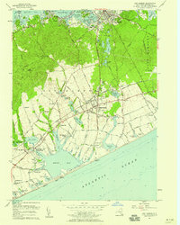
1956 Map of Sag Harbor
USGS Topo · Published 1958About this map
The hamlets and harbors of eastern Long Island are documented here during the mid-1950s, showing a landscape defined by its coastal ponds and the agricultural heritage of the South Fork. Bridgehampton serves as a central hub, where the Long Island Railroad passes through a network of potato fields and estates. To the north, the historic port of Sag Harbor is captured with its dense street grid and waterfront developments along Sag Harbor Cove, while the western edge features the protected shoreline of the Morton National Wildlife Refuge at Jessup Neck. The southern coast reveals a string of expansive water bodies, including Mecox Bay and Sagaponack Pond, separated from the Atlantic by thin barrier beaches. This survey provides exceptional detail for genealogists, mapping family-named roads like Daniels Lane and Hedges Lane alongside established institutions such as St Andrews Cem and the Experimental Laboratory near Mill Pond.
Find a feature on this map
99 named features on this map. Tap any name to fly to it.
Don’t see what you’re looking for? This feature index may not catch every label — zoom into the map to look around manually.
Map Details
Editions of this 1956 Sag Harbor Map
2 editions found
Other maps of this area

1903 · Sag Harbor
USGS Topo · 1:62,500

1903 · Gardiners Island
USGS Topo · 1:62,500

1904 · Sag Harbor
USGS Topo · 1:62,500

1904 · Shelter Island
USGS Topo · 1:62,500

1904 · Easthampton
USGS Topo · 1:62,500

1904 · Gardiners Island
USGS Topo · 1:62,500

1921 · Gardiners Island
USGS Topo · 1:62,500

1921 · Easthampton
USGS Topo · 1:62,500

1944 · Gardiners Island West
USGS Topo · 1:24,000

1946 · Sag Harbor
USGS Topo · 1:24,000