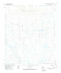
1971 Map of Sagavanirktok B-5
USGS Topo · Published 1973About this map
White Hills dominate the northern terrain of this 1971 Alaskan survey, which captures the remote landscape of the North Slope before extensive infrastructure arrived. This map documents a transitional period in Arctic transportation, highlighting the reliance on seasonal routes such as the Winter Road and Winter Trail. These paths reflect the logistical challenges of the era, where heavy movement was often restricted to the frozen months to protect the tundra and navigate the low-relief marshlands. The presence of the Base Line running through the center of the sheet underscores the systematic effort of the U.S. Geological Survey to bring formal cartographic structure to this unorganized wilderness. For researchers of North Slope history, the map provides a rare look at the original alignment of these early access routes across a landscape of countless unnamed lakes and ponds.
Find a feature on this map
4 named features on this map. Tap any name to fly to it.
Don’t see what you’re looking for? This feature index may not catch every label — zoom into the map to look around manually.
Map Details
Editions of this 1971 Sagavanirktok B-5 Map
This is the sole edition of this map. No revisions or reprints were ever made.
Other maps of this area

1951 · Sagavanirktok D-5
USGS Topo · 1:250,000

1952 · Umiat
USGS Topo · 1:250,000

1956 · Sagavanirktok
USGS Topo · 1:250,000

1956 · Umiat
USGS Topo · 1:250,000

1958 · Sagavanirktok
USGS Topo · 1:250,000

1964 · Umiat
USGS Topo · 1:250,000

1964 · Sagavanirktok
USGS Topo · 1:250,000
1971 · Sagavanirktok B-4
USGS Topo · 1:63,360
1971 · Umiat C-1
USGS Topo · 1:63,360
1971 · Sagavanirktok A-5
USGS Topo · 1:63,360