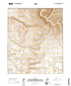
2017 Map of Sagavanirktok B-5 NW
USGS Topo · Published 2017About this map
White Hills dominates the northern landscape of this remote Arctic quadrangle, where the terrain rises in a series of distinct ridges and drainages. The mapping of this area, as presented by the U.S. Geological Survey, details the expansive topography of the North Slope. The presence of the Townships t2n r9e, t2n r10e, t1n r9e, t1n r10e, t1s r9e, and t1s r10e indicates the formal surveying of this wilderness into the Public Land Survey System. These grids provide a framework for understanding the undeveloped character of the region, where natural elevation and hydrography are the primary features, reflecting a landscape largely untouched by permanent settlement or infrastructure during this period.
Find a feature on this map
7 named features on this map. Tap any name to fly to it.
Don’t see what you’re looking for? This feature index may not catch every label — zoom into the map to look around manually.
Map Details
Editions of this 2017 Sagavanirktok B-5 NW Map
This is the sole edition of this map. No revisions or reprints were ever made.
Other maps of this area

1951 · Sagavanirktok D-5
USGS Topo · 1:250,000

1952 · Umiat
USGS Topo · 1:250,000

1956 · Sagavanirktok
USGS Topo · 1:250,000

1956 · Umiat
USGS Topo · 1:250,000

1958 · Sagavanirktok
USGS Topo · 1:250,000

1964 · Umiat
USGS Topo · 1:250,000

1964 · Sagavanirktok
USGS Topo · 1:250,000
1971 · Umiat C-1
USGS Topo · 1:63,360
1971 · Sagavanirktok B-5
USGS Topo · 1:63,360
1971 · Sagavanirktok C-5
USGS Topo · 1:63,360