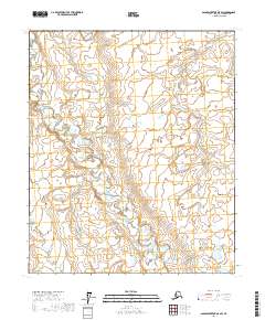
2017 Map of Sagavanirktok B-5 SW
USGS Topo · Published 2017About this map
Glacial landforms and an intricate network of thermokarst lakes dominate this section of the Arctic coastal plain, located south of the Beaufort Sea. The landscape is defined by the Public Land Survey System grids of T1s R9e, T1s R10e, T2s R9e, and T2s R10e. The lack of named human infrastructure or settlements on the sheet reflects the vast, undeveloped character of the North Slope during the early 21st century. The survey reveals a complex hydrographic pattern of small, scattered ponds and wetlands, typical of the permafrost-underlain tundra where drainage is restricted and seasonal freezing and thawing constantly reshape the surface topography.
Find a feature on this map
4 named features on this map. Tap any name to fly to it.
Don’t see what you’re looking for? This feature index may not catch every label — zoom into the map to look around manually.
Map Details
Editions of this 2017 Sagavanirktok B-5 SW Map
This is the sole edition of this map. No revisions or reprints were ever made.
Other maps of this area

1951 · Sagavanirktok D-5
USGS Topo · 1:250,000

1952 · Umiat
USGS Topo · 1:250,000

1956 · Sagavanirktok
USGS Topo · 1:250,000

1956 · Umiat
USGS Topo · 1:250,000

1958 · Sagavanirktok
USGS Topo · 1:250,000

1964 · Umiat
USGS Topo · 1:250,000

1964 · Sagavanirktok
USGS Topo · 1:250,000
1971 · Sagavanirktok A-5
USGS Topo · 1:63,360
1971 · Sagavanirktok B-5
USGS Topo · 1:63,360
1971 · Umiat A-1
USGS Topo · 1:63,360